
Case Study | Charge EPC — Santa Rosa Mobile Home Community
Utility Certainty for an Undocumented Residential Community
Charge EPC partnered with Exodigo to map underground utilities across a Santa Rosa mobile home community before converting direct-connected services to new metered service connections — locating nearly twice the utility footage found by premium locators and verifying Exodigo-only findings through potholing.
- 1.9xmore utility footage found
- 165 ftof phantom lines cleared
- 3/3blind potholes confirmed
Project Summary
A verified picture beneath occupied homes.
Charge EPC, a utility infrastructure construction company specializing in power and gas installation by open-cut and trenchless methods, was converting an existing Santa Rosa, California mobile home community from direct-connected services to new metered service connections. In communities like this one, records of gas, electric, water, sewer, and communications lines are effectively non-existent, leaving Charge to research, locate, and excavate around live systems feeding occupied homes. Charge engaged Exodigo to run a direct, head-to-head evaluation: alongside the subcontracted conventional (SUE) locating Charge already had underway, Exodigo independently mapped the ~1.5-acre site non-intrusively, and both sets of findings were put to the test through potholing.
THE CHALLENGE
No records, live services, dense routing.
Effectively non-existent records
No dependable documentation of line locations, depths, or materials anywhere across the community.
Active services feeding occupied homes
Every excavation carried the risk of striking a live gas, electric, water, or sewer line.
Dense, layered residential site
The new metered distribution piping had to be routed through conflict-free corridors, where a single missed line could turn a routine trench into a strike.
EXODIGO'S APPROACH
From undocumented conditions to verified routing.
Exodigo combined remote data preparation, non-intrusive multi-sensor scanning, and AI-enabled analysis to give Charge a defensible utility map before trenching began.
ExoInfo
Remote Data Collection & Integration
Formal utility records for the community were effectively non-existent, so Exodigo built the project's reference layer from the data available. Exodigo compiled and georeferenced current high-resolution aerial imagery as an accurate base, rather than relying on potentially outdated third-party imagery, giving the scan findings a reliable framework to be captured against and mapped to.
Utility Mapping
Non-Intrusive On-Site Reality Capture
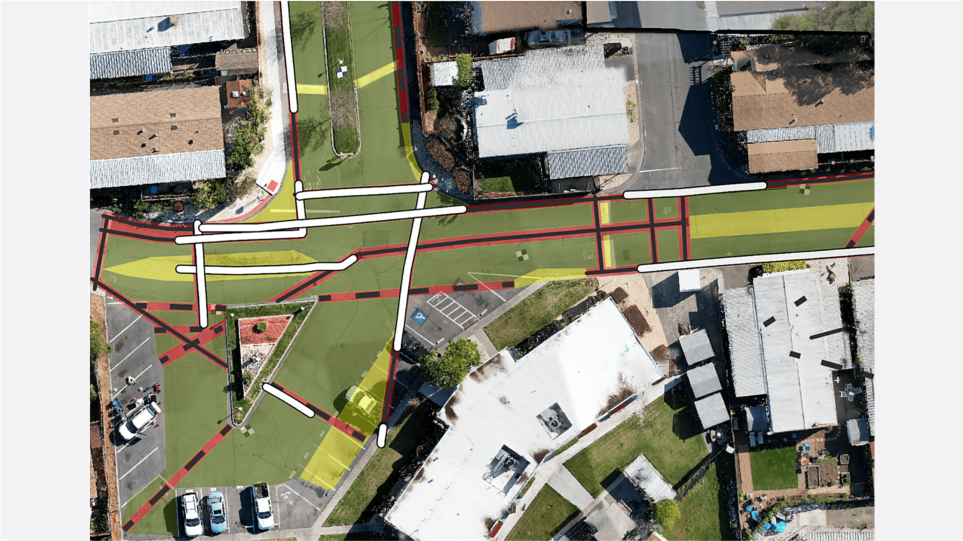
Exodigo scanned the ~1.5-acre community non-intrusively using the ExoCart platform carrying ground-penetrating radar, electromagnetic, and thermal sensors, traversing the site in a serpentine pattern with survey-grade positioning for accuracy beyond GPS alone. Because detection and classification are handled by Exodigo's AI rather than on-site operator interpretation, coverage was consistent regardless of the site's density or complexity. The fused, georeferenced data resolved both conductive and non-conductive lines — assigning confidence at the individual-utility level and reporting material and depth — and was delivered as a 2D Composite Utility Map with vertical elevations for direct comparison against potholing.
Impact
The proof behind every pothole.
1.9x More Utility Footage Found
Exodigo mapped roughly twice the utility footage identified by premium locators, including 685 feet of high-confidence lines they missed.
165 Feet of Phantom Lines Cleared
Exodigo identified locator-marked lines that were not actually in the ground, helping Charge avoid unnecessary dry holes.
3/3 Blind Potholes Confirmed
Charge pothole-tested three locations where only Exodigo showed a utility, and all three confirmed lines within inches of Exodigo’s mapped position.
Clear Routing for New Service
The final map gave Charge conflict-free corridors to route new metered distribution piping safely.
Fewer Surprises Before Trenching
Exodigo turned a site with effectively no usable documentation into a verified subsurface dataset Charge could build around.





Exodigo exceeded all our expectations. They found twice as many lines as what the premium locators found. This avoided a number of utility strikes…and would have been a major issue for our team and the execution of the project.
— Erich Metzger, Senior Director of Strategic Development, Charge EPC
Ready to build with greater certainty?
Bring us your next project. We'll show you what's beneath it.