Imagine combining an MRI, CT scan, and ultrasound into a single source of truth.
We do this for the underground.

We do this for the underground.

We scan entire areas in a crisscross, snake path pattern using our proprietary platform and transmitters to capture an unprecedented density of data points. This approach removes human error and bias from the scanning process and maximizes the completeness of the data we collect.
Unlike traditional “follow the line” methods, which start with existing records and visual hints like manholes or hydrants to infer locations, Exodigo scans every square foot/meter of the terrain to uncover all known and unknown subsurface assets, agnostic of external inputs.
Collects data non-intrusively without disturbing surface objects, breaking ground, or physically connecting to utilities (e.g., opening manholes)
Uses robust positioning techniques for accuracy in inches/centimeters
Exodigo scans with the most advanced sensors across multiple fields of physics. This approach compensates for limitations of individual sensor types and ensures that all buried assets - regardless of material and properties - are detected.
Captures 1000x more data than conventional locators by sampling every 0.4 inches (1 centimeter) of scanning
Eliminates error-prone on-site human decisions and calculations by processing in the cloud

Multi-Frequency Induced & Passive Electro Magnetics
Magnetic Gradiometer
TDEMI, FDEM, & AEM
Multi-Frequency Multi-Channel GPR
Underground objects impact their environment across multiple fields of physics. We detect them by combining the best available sensors for each discipline with precise geo positioning data.
As physics and sensors evolve, so does our platform. We constantly update our methods with the latest scientific developments and best-in-class hardware. The most common sensors include:
We add a high resolution image to the signals to detect any above ground indicators of underground utilities (e.g., manholes, hydrants, etc).
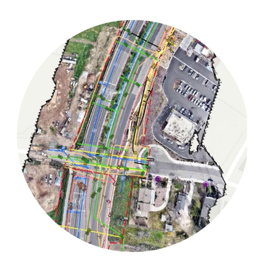
This fusion creates a synchronized, geolocated, multi-sensing data stack that enables our AI to build an accurate 3D model of the underground.


After we upload data to the cloud for analysis, Exodigo’s proprietary algorithms run physics simulations for all possible scenarios on the data sampled on-site to find the optimal prediction for the location of detected objects across the entire area.
Our algorithms are trained on our live database with terabytes of data from research and dozens of past projects across the world, and continually evolve as new data is added.
Through automation and AI, we can analyze orders of magnitude more data than conventional methods to find longitudinal or geometric phenomenon with different characteristics from their surrounding environment. Where it could take a highly trained geophysicist months to manually review this volume of data from a single site scan, our algorithms can process it in hours.
Using AI also minimizes human error throughout the process, particularly when it comes to maintaining consistent application of rules and quality assurance for repetitive tasks. Unlike humans, AI doesn’t require breaks and never gets tired or distracted.


While AI can solve most cases of object detection, we always include an underground expert as the “human in the loop”. Geophysics specialists and civil engineers on our team review all edge cases and verify the quality level of every map.
The result? The most complete, precise underground maps in the industry that our customers can trust for any stage of their project.
Break the subsurface status quo with our revolutionary approach to underground risk management. Experience the accelerated project delivery, cost savings, and safety and sustainability gains that Exodigo can help you achieve on your next project.
talk to usWe’ll share periodic updates and insights at the intersection of construction, technology, and underground risk management.